 Before the idea of NEXRAD came into existance, the National Weather Service relied on the idea of three types of thunderstorms: non-severe, severe, and tornadic.
As you see in the figure to the right, on a conventional radar, National Weather Service personal matched the color intensity of the return echos to the spectrum to judge if a thunderstorm was severe or not.
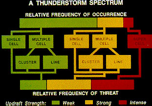
NWS also looked at the actual physical characterists of the storm as four broad categories: single cell storms, multicell cluster storms, multicell line storms, and supercell storms.
Before the idea of NEXRAD came into existance, the National Weather Service relied on the idea of three types of thunderstorms: non-severe, severe, and tornadic.
As you see in the figure to the right, on a conventional radar, National Weather Service personal matched the color intensity of the return echos to the spectrum to judge if a thunderstorm was severe or not.
NWS also looked at the actual physical characterists of the storm as four broad categories: single cell storms, multicell cluster storms, multicell line storms, and supercell storms.
The single cell thunderstorm has a lifetime of 20 to 30 minutes, but in that time frame, these storms are not strong enough or big enough to produce severe weather.
It is very rare to see just one single cell storm because most of the time the weak verticle shear or the gust front of another cell often triggers off the growth of another cell some distance away.
If the single cell storm does produce severe weather, the severe weather is brief and is called a pulse severe storm.
The severity is so short lived.
Pulse severe storms typically produce marginally severe hailstorm and/or a brief microburst, brief heavy rains and even the possiblity of a very weak tornado.
Single cell storms are very poorly organized that they can occur at random times and locations and because of this, it is very difficult to predict where they will occur and if they will produce severe weather.
The multicell cluster type of thunderstorm is by far the most common thunderstorm to occur.
This type of storm is a group or clusters of thunderstorms moving as one whole unit with each thunderstorm inside the unit at a different stage of life.
As this cluster of storms move along, each individual cell takes its turn to be the leader of the cluster with new cells usually forming to the west and south of the main dominant cell with the decaying storms to the east and north of the center.
One cell of the cluster might last 20 minutes, while the entire cluster of storms might last for several hours at a time.
Multicell storms are much stronger then the individual thunderstorm cell but it is a lot less powerful then the supercell thunderstorm.
These clusters are characterized by heavy rains, downburst winds of up to 80 miles per hour, moderate size hail, and an occasional weak tornado.
If severe weather occurs with this set up of storms, it occurs where the updrafts and downdrafts of the individual storms are close together.
The multicell line storm is a long line of severe thunderstorms which have a well-developed gust front at the leading edge of the line.
The multicell line is often called the "squall line" because the line of storms is a solid line with very few gaps and breaks in the line.
With this gust front ahead of the main line of storms, it forces the warm upstable air up into the updraft feeding the line with more juice and energy to live on.
The main updraft is at the leading edge, or east side of the line, with the heaviest rain and largest hail.
As the one of the storms begins to die off in this line of storms, they move to the backside of the line to allow the newer and more intense storms to eat up on the unstable air available.
The multicell line can produce medium size hail (up to golfball size), very heavy rain, and the possiblity for weak tornadoes.
Sometimes the strong downbust accelerates ahead of the main line and this creates a bowing affect to the storm.
This bowing affect, or bow echo, can develop with just isolated cells as well as squall lines.
Bow echos are very easy to pick out on radar but when it comes to seeing them with the naked eye, it is nearly impossible to pick out.
The supercell thunderstorm is by far the most organized and largest thunderstorm complex to have.
Although they are rare to occur, they pose an extremely high treat to life and property because they are so severe.
Just like the single cell storm, the supercell storm has just one main updraft, but this updraft is extremely strong reaching estimated speeds of 150 to 175 miles per hour.
The only thing that is different with a supercell storm to the other thunderstorm types is that the supercell storms have the element of rotation.
This rotating updraft of the supercell thunderstorm is call the mesocyclone because it helps produce the extreme severe weather such as: giant hail (greater then 2 inches in diameter), strong downburst of 80 miles per hour or great, and strong to violent thunderstorms.
high treat to life and property because they are so severe.
Just like the single cell storm, the supercell storm has just one main updraft, but this updraft is extremely strong reaching estimated speeds of 150 to 175 miles per hour.
The only thing that is different with a supercell storm to the other thunderstorm types is that the supercell storms have the element of rotation.
This rotating updraft of the supercell thunderstorm is call the mesocyclone because it helps produce the extreme severe weather such as: giant hail (greater then 2 inches in diameter), strong downburst of 80 miles per hour or great, and strong to violent thunderstorms.
 Of all the storms that are going on, only a small percentage (under 1 percent) are classified as being severe (large hail greater then 3/4 of an inch and or strong wind gusts greater then 58 miles per hour).
Even more startling is the fact, that less then 1 percent of these storms are being classified as severe and are producing a tornado.
Consequently, all thunderstorms are capable of producing severe weather, but just a few actually are able to produce hail, severe wind gusts, or tornados.
Of all the storms that are going on, only a small percentage (under 1 percent) are classified as being severe (large hail greater then 3/4 of an inch and or strong wind gusts greater then 58 miles per hour).
Even more startling is the fact, that less then 1 percent of these storms are being classified as severe and are producing a tornado.
Consequently, all thunderstorms are capable of producing severe weather, but just a few actually are able to produce hail, severe wind gusts, or tornados.